


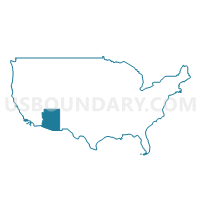
Yuma County--Yuma City PUMA, Arizona
About
Outline

Summary
| Unique Area Identifier | 192167 |
| Name | Yuma County--Yuma City PUMA |
| State | Arizona |
| Area (square miles) | 5,519.11 |
| Land Area (square miles) | 5,513.99 |
| Water Area (square miles) | 5.12 |
| % of Land Area | 99.91 |
| % of Water Area | 0.09 |
| Latitude of the Internal Point | 32.77394240 |
| Longtitude of the Internal Point | -113.91090500 |
Maps

Graphs
Select a template below for downloading or customizing gragh for Yuma County--Yuma City PUMA, Arizona


Neighbors
Neighoring Public Use Microdata Area (by Name) Neighboring Public Use Microdata Area on the Map
- Imperial County--El Centro City PUMA, CA
- Maricopa County (West) & Gila River Indian Community (Northwest) PUMA, AZ
- Mohave & La Paz Counties--Lake Havasu City PUMA, AZ
- Pima County (West) PUMA, AZ
Top 10 Neighboring County (by Population) Neighboring County on the Map
- Maricopa County, AZ (3,817,117)
- Pima County, AZ (980,263)
- Yuma County, AZ (195,751)
- Imperial County, CA (174,528)
- La Paz County, AZ (20,489)
Top 10 Neighboring County Subdivision (by Population) Neighboring County Subdivision on the Map
- Yuma CCD, Yuma County, AZ (138,997)
- Buckeye CCD, Maricopa County, AZ (62,196)
- Somerton CCD, Yuma County, AZ (49,570)
- Gila Bend CCD, Maricopa County, AZ (22,116)
- Parker CCD, La Paz County, AZ (20,489)
- Wellton CCD, Yuma County, AZ (7,184)
- Ajo CCD, Pima County, AZ (3,523)
- Winterhaven-Bard CCD, Imperial County, CA (3,052)
- East Imperial CCD, Imperial County, CA (1,266)
Top 10 Neighboring Place (by Population) Neighboring Place on the Map
- Yuma city, AZ (93,064)
- Fortuna Foothills CDP, AZ (26,265)
- San Luis city, AZ (25,505)
- Somerton city, AZ (14,287)
- Avenue B and C CDP, AZ (4,176)
- Wellton town, AZ (2,882)
- Donovan Estates CDP, AZ (1,508)
- Martinez Lake CDP, AZ (798)
- La Paz Valley CDP, AZ (699)
- Gadsden CDP, AZ (678)
Top 10 Neighboring Elementary School District (by Population) Neighboring Elementary School District on the Map
- Yuma Elementary District, AZ (99,267)
- Crane Elementary District, AZ (43,266)
- Gadsden Elementary District, AZ (25,269)
- Somerton Elementary District, AZ (21,579)
- Quartzsite Elementary District, AZ (6,162)
- Wellton Elementary District, AZ (4,038)
- Salome Consolidated Elementary District, AZ (2,763)
- Mohawk Valley Elementary District, AZ (1,597)
- Arlington Elementary District, AZ (1,472)
- Wenden Elementary District, AZ (815)
Top 10 Neighboring Secondary School District (by Population) Neighboring Secondary School District on the Map
- Yuma Union High School District, AZ (189,381)
- Buckeye Union High School District, AZ (65,817)
- Bicentennial Union High School District, AZ (10,921)
- Antelope Union High School District, AZ (6,370)
Top 10 Neighboring Unified School District (by Population) Neighboring Unified School District on the Map
Top 10 Neighboring State Legislative District Lower Chamber (by Population) Neighboring State Legislative District Lower Chamber on the Map
- Assembly District 80, CA (546,875)
- State House District 25, AZ (208,220)
- State House District 24, AZ (207,694)
Top 10 Neighboring State Legislative District Upper Chamber (by Population) Neighboring State Legislative District Upper Chamber on the Map
- State Senate District 40, CA (1,018,606)
- State Senate District 25, AZ (208,220)
- State Senate District 24, AZ (207,694)
Top 10 Neighboring 111th Congressional District (by Population) Neighboring 111th Congressional District on the Map
Top 10 Neighboring Census Tract (by Population) Neighboring Census Tract on the Map
- Census Tract 116, Yuma County, AZ (8,463)
- Census Tract 115.04, Yuma County, AZ (8,339)
- Census Tract 118, Yuma County, AZ (8,316)
- Census Tract 9.05, Yuma County, AZ (8,171)
- Census Tract 114.06, Yuma County, AZ (7,538)
- Census Tract 109.11, Yuma County, AZ (6,935)
- Census Tract 9.07, Yuma County, AZ (6,563)
- Census Tract 115.03, Yuma County, AZ (5,441)
- Census Tract 11, Yuma County, AZ (5,164)
- Census Tract 6, Yuma County, AZ (5,158)
Top 10 Neighboring 5-Digit ZIP Code Tabulation Area (by Population) Neighboring 5-Digit ZIP Code Tabulation Area on the Map
- 85364, AZ (74,904)
- 85365, AZ (46,558)
- 85349, AZ (25,517)
- 85350, AZ (21,214)
- 85367, AZ (20,429)
- 85354, AZ (6,645)
- 85356, AZ (4,539)
- 85346, AZ (4,423)
- 92283, CA (3,158)
- 85333, AZ (790)